How To Find Your Property On FEMA’s Flood Insurance Rate Maps

What are FEMA flood maps?
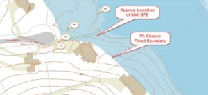
FEMA’s Flood Insurance Rate Maps (FIRMs) or just Flood Maps are provided after a flood risk assessment has been completed or updated for a community.  This study is known as a Flood Insurance Study.  The FIRM gives you the Base Flood Elevations (BFEs) and insurance risk zones in addition to floodplain boundaries.  The FIRM may also show a delineation of the regulatory floodway.

Once the “insurance risk zone”  (commonly referred to as the flood zone) is determined, actuarial rates, based on these risk zones, are then applied for newly constructed, substantially approved, and substantially damaged buildings.  FEMA uses these rates to determine the insurance rate you will pay for flood insurance

FEMA’s Digital Flood Maps

FEMA discontinued the production and distribution of paper flood maps in 2009 as part of its Digital Vision Initiative. This affected all the Flood Maps, boundary information, and study reports. However, clients can still view the products for free through their website or buy them in digital format.

To view these flood maps online, go to FEMA’s Map Service Center and key in your address (hi-lited area shown here) search for your home.  This will prompt you to then select the map that covers your area.  The Flood Maps are somewhat cumbersome to use online. It is best to go through the tutorial on the bottom right of the address search page for an easier and more effective use of the GIS map.

author avatar
Surveyor

More Posts

Wooden fence along a property line showing why homeowners may need a boundary survey to resolve disputes
boundary surveying
Surveyor

Boundary Survey: The Fastest Way to Settle Property Disputes

Imagine this: you wake up one morning and notice your neighbor building a brand-new fence. It looks great, but something feels off. Is it crossing into your yard? Should you say something? Many homeowners run into this exact situation, and the arguments that follow can get ugly. The truth is,

Read More »
topographic survey - Dayton Ohio skyline
land surveying
Surveyor

Why Dayton Projects Start With Topographic Surveys

Starting a construction project in Dayton is exciting. Whether you’re building a home, adding space for your business, or improving your property, you want things to go smoothly from the very beginning. That’s why many successful projects in Dayton begin with topographic surveys. These surveys help find problems like uneven

Read More »

Selling a Floodplain Home? Get the Elevation Certificate

Selling a home is rarely simple. But if your property is in a floodplain, like some neighborhoods in Toledo, there’s an extra step that can make or break your deal — getting an elevation certificate. Many sellers don’t think about this document until a buyer or lender requests it. By

Read More »
Land surveyor performing a boundary survey in a Cleveland residential neighborhood
boundary surveying
Surveyor

Why You Need a Boundary Survey

In Cleveland’s tightly packed neighborhoods, every square foot of land counts. Whether you’re installing a new fence, adding a garage, or landscaping your yard, you need to know exactly where your property ends—and your neighbor’s begins. That’s where a boundary survey in Cleveland OH becomes essential. Without one, even a

Read More »
Cleveland Ohio skyline and commercial buildings—ALTA surveys are essential for urban property transactions.
alta survey
Surveyor

Don’t Skip the ALTA Survey: It Could Save Your Investment

In the rush of closing a commercial real estate deal, it’s easy to overlook one critical step—the ALTA survey. But in a city like Cleveland, where aging infrastructure, legacy easements, and fast-moving development projects intersect, skipping this survey can be a costly mistake. Whether you’re buying, financing, or redeveloping a

Read More »
Surveying equipment set up on a rural site in Ohio to conduct a topographic survey, capturing elevation and land features before construction planning.
land surveying
Surveyor

Do You Need a Topographic Survey Before Building?

Thinking of Building? Here’s Why a Topographic Survey Should Come First Before any shovel hits the ground, smart builders and homeowners take one essential step: getting a topographic survey. Whether you’re building a new home, a commercial warehouse, or preparing land for development, a topographic survey ensures your plans align

Read More »